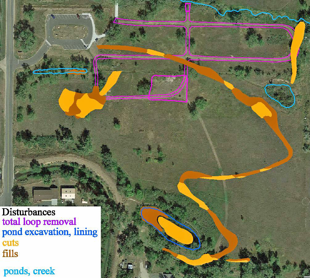
The gravel loops in the lowlands, presently used by walkers and pets, are to be totally removed, destroying their function as a levee confining Van Bibber Creek. The replacement is a single curved path to the south made durable with fine gravel. There is also a small lowland loop of mowed grass, not durable for walking traffic.
The upper (south) pond is to be excavated, lined, with dirt replacement, to hold water temporarily for irrigation of the lowlands.
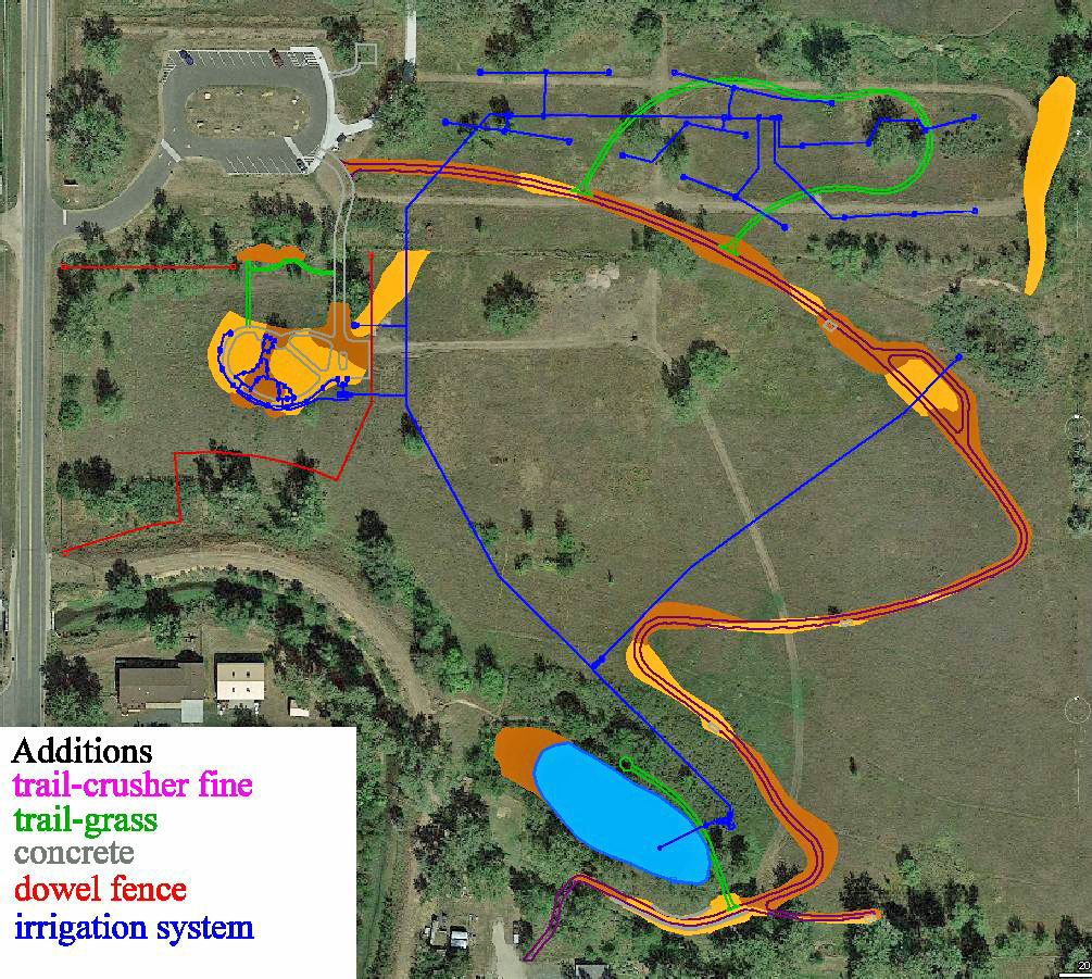
A picnic shelter and playground are to be built south of the parking lot.
Total cost estimate: $700K as of June, likely to rise 30%, from property taxes.
Main issue: Conservation Easement allows natural and agricultural uses and irrigation. The District is not choosing agriculture and its water needs. By definition, all natural areas must receive precipitation only. Therefore the plans for the irrigation system and lining of the south pond (which are costly) violate the natural status and waste water on prairie grasses that do not need it.
You may send your comments to:
Adam Blackmore at ablackmore@prospectdistrict.org
District Manager
Prospect Recreation & Park District
4198 Xenon Street; Wheat Ridge, CO 80033
303-424-2346, fax 303-424-4066
info@prospectdistrict.org
www.prospectdistrict.org
and Jim Zimmerman at zimzimzim@aol.com. Chairman of Board of Directors and of Prospect Foundation which oversees the Serene Conservancy for Prospect
Depending on your interest in the Serene Conservancy future open space you might have an opinion on:
Trails - If you use the 3 lowland gravel loops for walking and pet exercise, how do you feel about the plan to totally remove those loops down to the old soil level?
Is the curving proposed trail to the east and then uphill to the top (south) a good replacement for your needs? It is to be more durable and with a slope that is wheelchair accessible. If you use the present, more direct, grassy path between the south entrance and the lowlands, the proposal is to abandon it. Is it a better route for you between the top and bottom? Not mentioned in the proposal is the possibility of retaining that simple existing path and strengthening it for more durability with traffic.
Irrigation - The interior 13 acres are supposed to be restored to natural habitat according to the conservation easement. That has essentially been done, converting the lowlands from a weed patch to a prairie grassland, and accomplished without any irrigation water. But "natural" means that the only water it receives should be from precipitation, not irrigation from ditch water rights. From your visual observations of the property and the entire Van Bibber Open Space, does it appear that the natural vegetation needs irrigation water? If not, then the proposed irrigation wastes precious water for no good purpose and wastes the taxpayer money to establish the irrigation system. Any supplemental water will enhance the productivity of invasive noxious weeds that do not belong on this property.
If irrigation is not needed, then there is no need to excavate the southern (upper) pond, line it with a water barrier, and refill its bottom with dirt and vegetation debris. That activity would also be an expensive use of taxpayer money. The water rights could be sold to where the valuable water is needed.
The present leakage from the ditch of irrigation water is enlarging the cattail swamp in the southern highlands and dampens adjacent properties. That leakage could be lessened by lining the ditch with fabric, opened at the top for easy cleaning.
Cost - The cost of Prospect’s proposal appears to be approaching a million dollars with likely overruns. That is to be paid by the tax mil levy on properties within Prospect’s district. A much better environmental and financial alternative would be to abandon all of the proposal’s plans for the interior 13 acres that is set aside by the legal conservation easement. It has already been restored to natural habitat and should not suffer major disturbances. That means no upper pond lining, no irrigation system, and no trails designed in the proposal, thereby saving the bulk of the costs. The proposed picnic shelter and possibly the playground within the 5 roadside acres is in accord with the conservation easement and could be built there at a location above the flood plain.
More details and illustrations are in a PDF document. (from Dr. Ed Holroyd, former caretaker. eholroyd@juno.com)