Rocks
More than a year before our January 2026 tour of Ethiopia, our leader asked me to prepare a geologic summary of Ethiopia from the perspective of the Biblical time scale initiated in the book of Genesis. From that "Young-Earth Creation" interpretation the major geologic events are within a timespan of less than 10,000 years, and likely a little more than 6,000 years. Major geology happened in Creation Week on Day 3. Then there was the global Flood of Genesis 6 to 9, resurfacing the Earth in about a year about 2460 B.C.. Obviously, such recent interpretations are at great odds with the secular timescale of millions and billions of years. This chapter of the Trip Report for Ethiopia will extract some things from the previous, more technical, report about the geology of Ethiopia.
Creation Rocks
On Day 3 of Creation Week God made land emerge from under the global ocean. Likely that was done by separating rock-forming minerals into rocks of about two different densities. Varieties similar to coarse-grained granite with major silica content formed the basement rocks of the continents with lesser density, floating high on the Earth's Mantle like a scum. The Mantle and ocean floor contents remained with denser rocks similar to basalt.
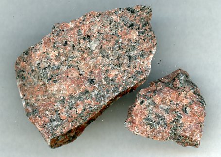 granite - continents
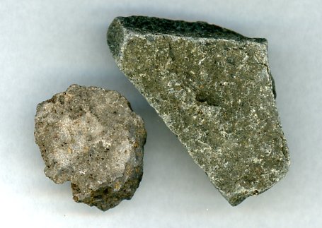 basalt - ocean floor,
Both of these basic rock types come in a variety of colors and textures.
Metamorphic Rocks
When rocks of any original type are subjected to intense pressure and temperature, they are changed into metamorphic rocks. The presence of water and carbon dioxide can lessen the melting temperature. Lesser alteration squeezes the rocks into thinner sheets called schist, which can have shiny surfaces. Greater alteration can create banded rocks named gneiss (pronounced "nice"). Original minerals are typically transformed chemically into new mineral types, and crystals are re-shaped. These grades of metamorphic alteration are important for interpreting the amounts of pressure and temperature applied to the rocks in the past.
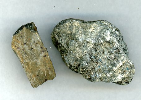 schist - low grade
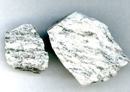 gneiss - high grade
Vertical Sequence
One of the early laws of geology, with occasional exceptions, is that in a vertical sequence, lower layers are older than high layers. Secular scientists (with initial contributions and namings from Bible-believing scientists) have created what is called the geologic column. It names a general sequence in the order of placement in most areas of the world. Times in millions of years are applied to transitions between the periods. The following diagram is an example based on the secular geologic column.
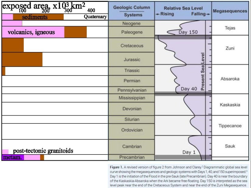
The middle gray column is a list of typical System names, with the oldest at the bottom. There are tics at the right (edge of pale purple) that is a supposed linear time scale for millions of years. At the far right are names of Megasequences, a new concept, that recognizes repeats of types of depositions, such as coarse grains first, fining upwards to mud grains as flooding calms down. The pale purple suggests ocean water depths over the continents, where deepest water has the graph line to the left. The author of this diagram has labeled Day 1, Day 40, Day 150, in an attempt to classify the geologic column with days mentioned in the global Flood of Genesis 6 to 9. He suggests that the greatest water depth happened after the ending of the Cretaceous period. (When the dinosaurs supposedly died out.) Then the Flood waters receeded, initially in very broad sheet flow of hundreds and thousands of kilometers width, followed by channelized flow that carved out river valleys.
At the left I have graphed the total areas of exposed geologic layers of basic types (igneous in pink, sediments in brown, metamorphics in purple) in Ethiopia and Eritrea. Creation rocks are at the bottom. Then there is a major gap with no new layers of anything. That indicates any geologic activity was the erosion of existing landforms (by rapidly moving Flood waters), not any deposition of sediments or of volcanic layers. The surface exposure locations and order of subsequent layers are shown in the maps that follow.
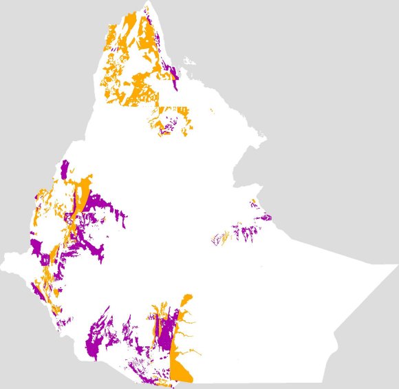
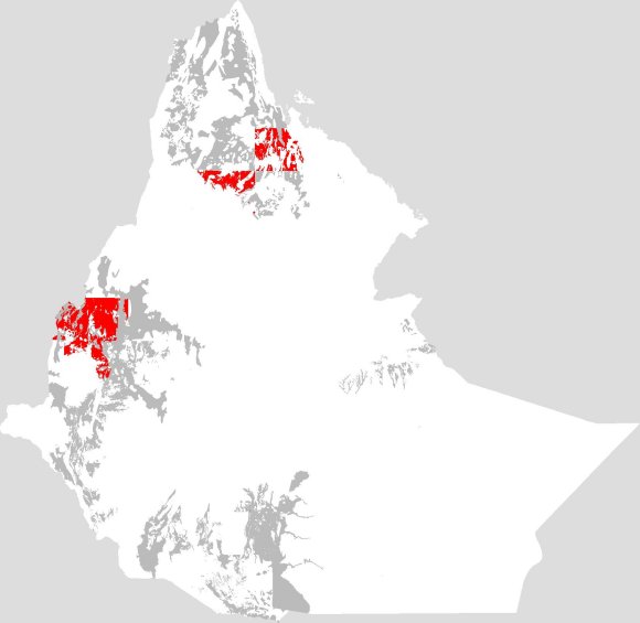
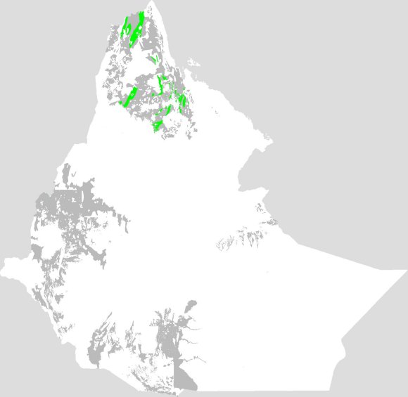
In these maps, white is for areas obscured by more recent layers. Gray is for previous, older layers. Red is for igneous layers, including volcanic. Green is for sediment layers. Orange and purple are for metamorphic layers, altered by great pressure and hot temperature.
There are a few obvious flaws in these maps, typically shown by straight lines. Those lines are the edges of fine scale geologic maps used in this study. Rock formation types may differ from older coarse scale maps used to fill in areas not covered by detailed maps.
The Precambrian rocks are usually the basement rocks of the continents worldwide, topped by the Great Unconformity above which any previous rocks were eroded to semi-flat surfaces. They are usually crystalline rocks like granite varieties, or metamorphic rocks which were subjected to mineral changes and distortions by heat and pressure. Sedimentary Precambrian are uncommon. Fossils are extremely rare and almost always tiny. Biblically these are usually considered to be rocks from Creation Week, plus rare examples from the years before the Flood, plus alterations from the early stages of the Flood year. Precambrian rock type descriptions that included “schist” were summarized as low grade metamorphic rocks, altered by intermediate temperatures and pressures, and colored orange in the first map. Those that included “gneiss” were summarized as high grade metamorphic rocks, being altered by the greatest temperatures and pressures, and colored purple in the first map. Precambrian rocks are actually everywhere, but do not have surface exposures by which to interpret them.
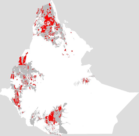
The next map shows the distribution of Precambrian rocks considered igneous, such as volcanic and lavas. There are two small regions (red) indicating heating possible from plumes in the Earth’s mantle. It cannot be known if these two regions are actually connected because of the obscuring layers above (white).
The next map shows the uncommon Precambrian sediments in green. They are only in the northern parts of Ethiopia and Eritrea. They could indicate erosion products of nearby Precambrian crystalline rocks.
The next map shows areas that may indicate granites that are younger than the other Precambrian rocks. If so, their distribution could indicate greater heating from Earth’s mantle plumes below the region. These are somewhat massive intrusions.
There are no exposures of rock layers considered to be Paleozoic. Elsewhere in the world, these would be the first sediments attributed to the Flood, usually containing marine fossils. This indicates that this region of Africa was undergoing severe erosion, possibly from very fast movement of relatively shallow Flood water that causes cavitation that will quickly destroy even the hardest rocks. All resulting rock powders and rock fragments were moved far away from this African region before being deposited as sediments elsewhere in the world.
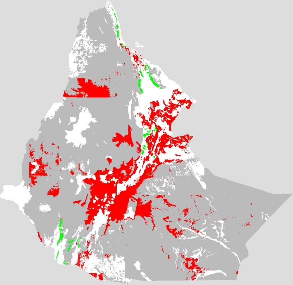
The next map shows Mesozoic rocks (Permian to Cretaceous), all sediments (green) and no volcanics. These areas may actually be connected below the younger (white) obscuring layers. They indicate that in nearing the peak of Flood year inundations the water has slowed enough for widespread deposition of marine sediments. The uniformly widespread distribution of these sediments indicates broad sheet flow movement of water, in swaths hundreds and thousands of kilometers wide, generally ignoring any underwater landscapes. Channelized flow, as in modern rivers, would create smaller alluvial fans (deltas) in deposition regions.
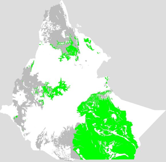
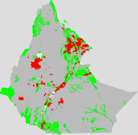
The next map shows Paleogene (Paleocene to Oligocene) rock layers. Red shows major new volcanic layers. Its large area indicates significant heating from a large mantle plume. That heat would raise elevations in Ethiopia because of the thermal expansion of the rocks. A major splitting of the landscape was about to begin. Green shows the final deposition of marine sediments in the far east as the rest of Ethiopia is raised above sea level.
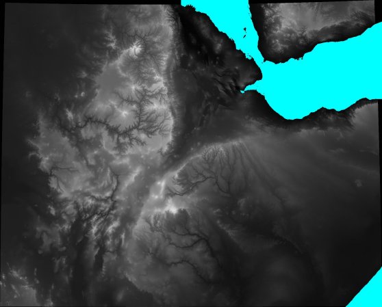
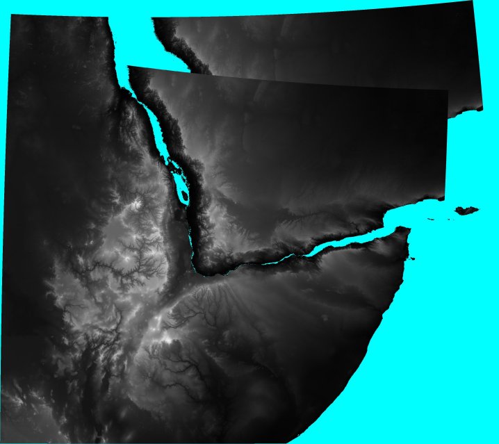
The next study works best with elevation data for the region. Maps with present sea level edges do not work. In the following image the coloring is black for present near-sea level topography grading to white for high elevations. Cyan is for ocean areas. The Arabian geologic plate is in the upper right. For the following image, showing a larger view, I extracted part of Arabia, slightly rotated it (7.5 degrees), and moved it up to the higher the African topograph. It fits nicely there. It is at this geologic time that the plate tectonics and continental drift mechanisms split the Arabian plate out of the northeastern quadrant of Ethiopia and moved it away to the northeast, where it is today. At the same time of that split, the Rift Valley opened diagonally across the more southern Ethiopia.
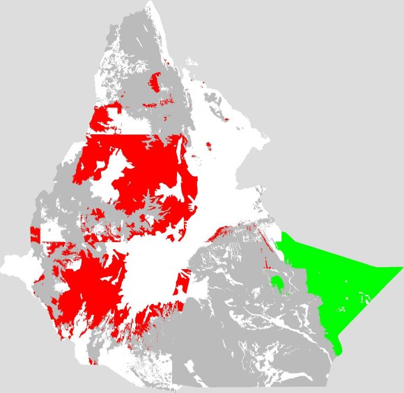
The next map shows Neogene layers (Miocene and Pliocene, but some simply are Tertiary which could include Paleogene). The red (volcanics) pattern shows the opening of the rift valley and the filling of the northeastern void left by the departure of the Arabian plate. Sediments (green) are minimal and indicate only local erosion and deposition. The region is now essentially above sea level and post-Flood.
The final map of the series shows Quaternary layers (Pleistocene and Holocene, basically the most recent). Volcanics (red) are now minimal showing just some small hot spots. The void left by the departure of the Arabian plate continues to fill. Sedimentation (green) has increased as erosion releases material for nearby deposition.
 The white areas are now just lakes.
This study does not address the major erosion features of Ethiopia. There are very broad regions of missing geologic layers likely resulting from the sheet flow drainage patterns as Flood waters drained from the area. Later channelized flow of draining Flood waters carved the large canyons. The present rivers in those channels have insufficient water to have carved the canyons in which they reside.
Navigate to other topics:
Home,
Rocks,
Pre-Axum,
Axum,
Lalibela,
Gondar,
crosses,
Palace Museum,
Cultural Dinner,
Hossana,
Synods,
dwellings,
transport,
Ethiopian Birds